
History can also be a Treasure Trove

Some dates area indelibly etched into our memories. There are the happy ones, like weddings and births, but of course, there are the sad ones, both personal and those of sweeping importance, that hit us our of the blue. I remember my father talking about what he was doing he heard about Pearl Harbor being attacked; I remember what I was doing when a teacher came into our high school study hall to tell us President Kennedy had been shot.
North Taos Pueblo, September 12, 2001

My husband and I were vacationing in New Mexico when the 9/11 attacks changed the world. Unable to leave until the emergency was over, we revisited the Pueblo north of the modern town of Taos. This site lies below a number of airplane flight paths, so normally a modern photograph would have con trails in the sky; however, as almost all civilian aircraft were grounded (special permission was required to fly), this is a rare modern view of the North Pueblo under the sky as it had existed for centuries.
North Taos Pueblo, 1920s

The photogravure, above, was published by Plimpton Press, circa 1925, from the Curtis plate (public domain).
According to oral tradition, the adobe structures at Taos Pueblo were built between 1000 & 1450, and today are much the same as they were when the Spanish first came, seeking the legendary golden cities of Cibola. They are considered the oldest continually inhabited structures in the United States and have been declared a World Heritage Site by UNESCO.
The Pueblo is closed due to the pandemic.
One of my readers asked me what I knew about the history of the name “Salton,” as in the Salton Sink, Salton Sea, Salton Station on the Southern Pacific Railroad line. I reread my post on the New Liverpool Salt Works and discovered I had made a typographical error; the salt works were incorporated in November 1883, not 1893! I am grateful for the opportunity to correct my error.
If you are interested, the earliest reference I can find regarding the name Salton was an article in the May 11, 1884 edition of the Los Angeles Herald:
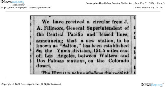
All the earlier maps show names for the area such as the “Colorado Desert” (1856); Coahuilla Valley, Cabazon Valley, Frink Dry Lake (late 1870s). By the time of the natural overflow of the Colorado in 1891, Salton was in use.
FYI: Walters became Mecca.
The Southern Pacific Railroad completed tracks from Los Angeles to Indio, California, in 1876; the following year the rails were extended to Yuma, and by 1883, the “Sunset Route” from Los Angeles to New Orleans was completed, opening a new route for California produce to reach markets.
As part of the railroad line, a few miles south of Indio, a 3 car side spur was built at the site of present day City of Coachella. From there mesquite & ironwood were loaded onto boxcars for stove wood. Around 1900, Jason L. Rector pitched his tent and began harvesting wood for his employers, the Southern Pacific Railroad Co. And the A. N. Towne Estate. In 1901, he quite his job, tapped a well at an artesian spring, built an adobe house, and in 1902 organized the Coachella Valley Produce Association.*

With irrigation now possible, cantaloupe became “king.” Indeed, Rector’s well was located on Cantaloupe Avenue (now Grapefruit Blvd./Highway 111).


There is debate about how the name came about, but there is no debate that the people in the area did not like the name Woodspur. The main two theories are that Coachella was a compromise (or cross) between Cahuilla (or Coahuilla, name of the local tribe) and Conchilla (Spanish, after the small shells found all over the area from when it had been underwater), or that it was a printer’s typographical error. The oldest “first person” account I have found is a letter from Elmer Proctor.**
What is in a Name? Fast forward to the late Twentieth Century, when annual the world famous Coachella Music Festival began. *** Today the two names, Woodstock and Coachella, are often linked, but could it have been Woodstock and Woodspur?
* From the biography of Jason L. Rector in History of Riverside County California with Biographical Sketches by Elmer, Wallace Holmes, Historic Record Company, Los Angeles, 1912.
Since Mr. Rector was still alive and active in 1912, I assume this information is correct.
**Desert Magazine, Palm Desert, November 1945, page 33; excerpts from letter to the editor from Elmo Proctor:
“A United Stites department of the interior engineer (I think his name was Mendenhall), by government authority, had made a survey of the Salton Sea quadrangle and it was suggested that then was an auspicious time to give the valley a more appropriate name. Suggestions were asked for. The name “Conchilla,” submitted by Mr. Tingman, was chosen by a vote of the few prospectors, homesteaders and railroaders present in the small gathering.
I was present when the maps arrived in Indio giving the valley its new name. Must have been about 1898. Before that it had been called “Salton Sea Sink.” I was a clerk in A. G. Tingman’s store, one of the two (the other belonged to a Mr. Talent, also in Indio) that served railroad and desert people for over a hundred miles in all directions.
I well remember how badly put out Mr. Tingman was when the maps arrived and it was found that the engineer’s longhand was so unreadable that the name had been interpreted “Coachella.”
When I was in elementary school in Coachella, the little shell version (Conchilla) was what I was told.
*** The festival is actually held in a still rural area annexed by the City of Indio.

My parents had a heavy earthwork construction company; during my childhood, it was headquartered in Coachella, CA, in the American Southwest. Post World War II, there was a lot of water infrastructure being built, both new plans but also projects that had been delayed due to the War. I spend a lot of my young days looking out car windows as we went on road trips to check out potential job sites. I remember seeing lots of funny, tiny houses dotting the rural, mostly deserted countryside of the western US, so different from my home surrounded by agriculture.
When I asked my mother about some in the desert; I remember her telling me those were cabins built by city people who wanted to get away on weekends. As I grew older many of the tiny houses grew shabbier and then they started disappearing.

The Small Tract Homestead Act of 19381 opened the door to homesteading 5 acre parcels of public land; “settlers” had to stake their claim, and erect a minimum 192 foot cabin, costing at least $300 in building materials within 3 years, plus comply with the government paperwork. In 1955, the size of the required building became 400 square feet. By the 1970s, the boom of homesteading a “get away” cabin had waned, and in 1976, the act was repealed.
The ones near Interstate highways are pretty much gone, but on the back roads they still exist, ranging from abandoned, collapsing structures to ones that sport new windows and paint. There are also “builtmores” where the owners enlarged the homes, turning them into more substantial homes. Of course, this was more practical in areas where electricity and water became available.

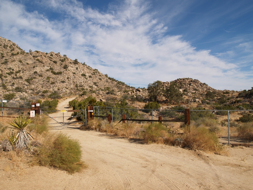
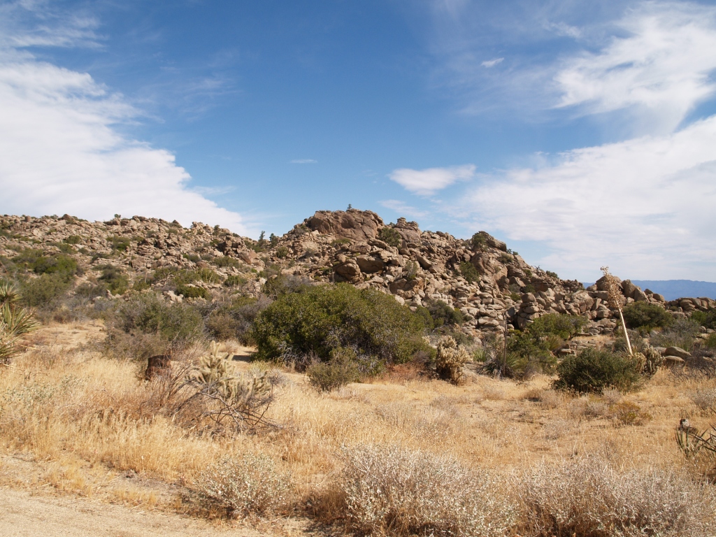
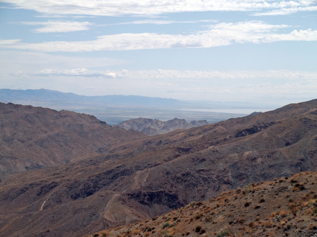
When I was appointed to the Governing Board of Coachella Valley Mountains Conservancy, I became involved in the process of acquiring land for conservation in the Coachella Valley and surrounding foothills and mountains. A lot of the land we’ve helped preserve in perpetuity has been by purchase of 5 acre parcels (mostly vacant, always from willing sellers), piecing together larger areas to protect wildlife (animal and plant), so future generations can enjoy majestic scenery in our part of the Southwest.

Desert X, a mostly outdoor art exhibit spread across the valley, held in alternative years, was once again created, despite the pandemic. One of its great advantages was the ability of the public to go, for free, to sites without close contact to others. Off a parking lot in Palm Desert, CA, Kim Stringfellow2 erected s small (122 sq. ft.) cabin based on the jackrabbit cabins; furnishing it in the manner of those early cabins.


1 In the midst of the Great Depression, there were a lot of Veterans from World War I who were homeless; after the horrors of trench warfare, many wanted space around them. However, World War II was looming and building materials were being diverted from the civilian market to war production, slowing down homesteading under the Act.
2 My daughter gave a copy of Stringfellow’s Jackrabbit Homestead for Mother’s Day, 2021, bringing back so many memories. If you are interested in more information on this latter day pioneer effort, I highly recommend checking out kimstringfellow.com and jackrabbithomestead.com. Her main focus is on the cabins of Wonder Valley north of Joshua Tree National Park, and east of Twentynine Palms, CA.
Being an aging Desert Rat myself, I am drawn to the story of Nina Paul Shumway. She came to the Coachella Valley with her parents, brother & first husband in June 1909, where her father started a date ranch and eventually became president of the Coachella Valley Date Growers Assn. She wrote about her life in the desert valley in Your Desert and Mine (I cherish my mother’s autographed first edition).
But, even confirmed Desert Rats yearn for cooler weather when the temps top 120F (48.9C) in the summer. She and her husband, Percy Stephen (Steve) Shumway* had long explored the Santa Rosa Mountains and in 1932, discovered Section 25,Township 6 south, Range 5 east of the San Bernardino Meridian; they subsequently were advised by the Land Office in Los Angeles, that a grazing Homestead of 640 acres** could be claimed, under the Stock-Raising Homestead Act of 1916.*** They had to wait months for the application papers to be sent from Montana. To qualify, they had to increase the value of the land by at least $1.25/acre, and at least half of that had to be done within 3 years; they also had to establish residence on the land, which Nina fulfilled by staying there for 7 months out of the year, while Steve worked in the Coachella Valley and traveled to the homestead as often as he could (usually twice a week).


Named “The Tors” by the Shumways, the rocky section was not a place for cultivation of crops, required under earlier homestead acts. Cattle belonging to neighbors did forage on the land.


I have seen photos of the Shumways at the fireplace; on the mantel they had several Cahuilla pots they had found, and which were ultimately given to the Desert Museum (today the Palm Springs Art Museum).
On the 13th of July, 1938, the last grazing homestead patent in California was issued to them, signed by Franklin D. Roosevelt. Sadly, in 1945, after a “beautiful day entertaining guests on the mountain,” Steve Shumway passed away from a massive heart attack.

Nina eventually had a house built in Palm Desert and spent part of the year there, and part at “The Tors.” By 1963, she was ready to move on, spending 10 years in Tucson, Arizona, and another 10 years in Palm Desert, passing away in 1984 at the age of 95.
Irene Rich, a silent screen actress and her daughter, Frances Rich, actress and sculptor, had purchased the “The Tors,” renamed it Shumway Ranch, and preserved the house built by the Shumways. Before her death in 2007, Frances Rich donated the Ranch to the Living Desert in Palm Desert. I went on a tour of the property once while the Living Desert owned it; a caretaker lived on the property and the Shumway house was empty.


Not able to feasibly integrate a program on the ranch with their zoo on the valley floor, in 2014, the Living Desert contacted the Coachella Valley Mountains Conservancy (CVMC), offering to sell the ranch. From January 2007 to the present, I have been the Calif. State Senate Appointee to the Governing Board of CVMC**** and, I am happy to say after a lot of negotiating, on June 26, 2017, the California Department of Fish and Wildlife took title to the ranch. In September the Department transferred jurisdiction over approximately 10 acres with the historic Shumway buildings to CVMC.

Conservancy operations and funding are limited by State statute, so while it retains title to the 10 acres, it is not really suited to open and operate the property, especially the structures, to the public. An operating/lease agreement has been signed with a separate non-profit organization, ShumwayRanch.org,***** created by community members with the hope they can open it despite the challenges of providing public restrooms, parking, fire fighting access, etc.

Ironically, on June 13, when I started putting together this article, a wildfire broke out about 3 miles from the Ranch. It burned 341acres and was fully extinguished June 21st, after destroying 2 houses and damaging 3 in nearby Pinyon Crest. Thanks to the valiant efforts of the fire fighters in an intense heatwave, the Ranch was not touched.
This blog is based on Nina Paul Shumway’s book, Mountain of Discovery (1992) and her article, Hard Rock Homesteaders (Desert Magazine, Sept. 1939); and my lifetime in the region
*or Steven; I have seen both spellings, but it is STEPHEN on his gravestone
** 640 acres is one square mile; 259 hectare. The ranch is now part of the Santa Rosa and San Jacinto National Monument, and is adjacent the San Bernardino National Forest.
*** To be eligible to be a homestead the US Secretary of the Interior had to decide that the lands were “chiefly valuable for grazing and raising forage crops, do not contain merchantable timber, are not susceptible of irrigation from any known source of water supply, and are of such character that six hundred and forty acres are reasonably required for the support of a family.” Sec. 2 of the Stock-Raising Homestead Act of 1916.
****Property bought with a grant from the CVMC, or directly by the Conservancy, is subject to a deed restriction placing it in conservation in perpetuity. The total sale was $1.565 million from a combination of government agencies.
*****Although sympathetic to their goals, I am not affiliated with ShumwayRanch.org.
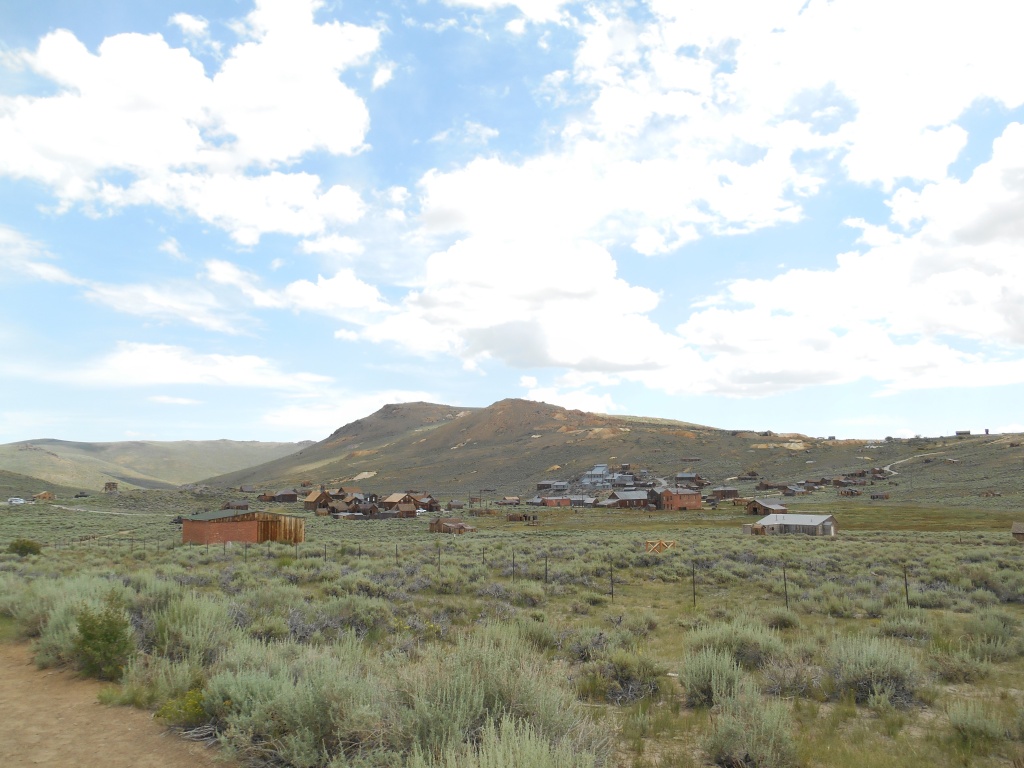
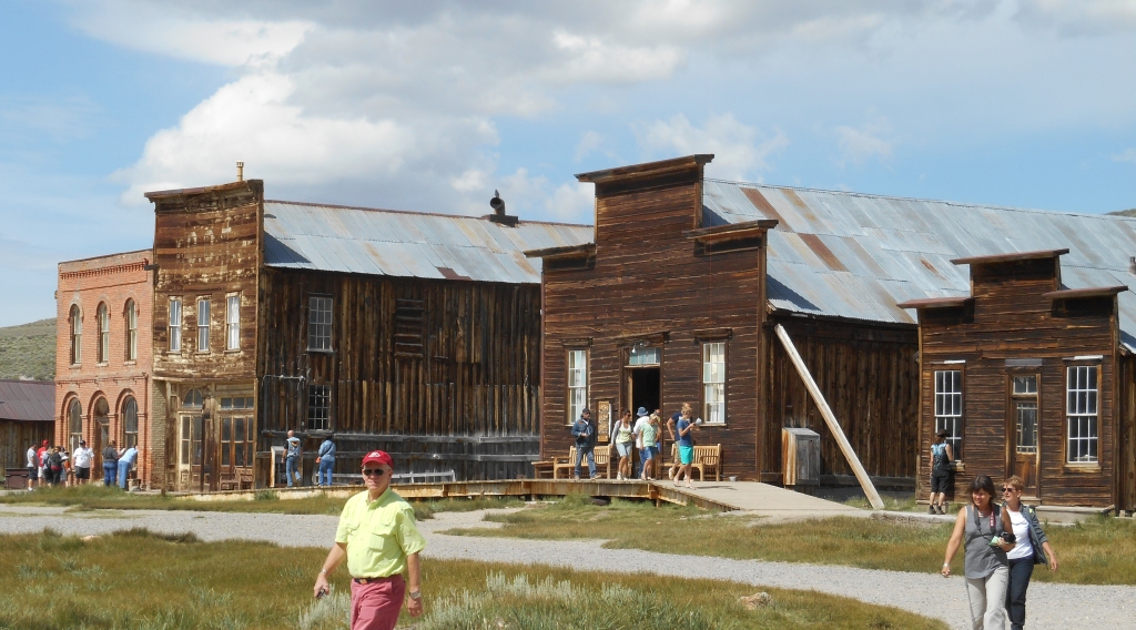
In the California Sierra Nevada Mountains, down a side road off US 395 (last three miles graded but not paved), lies the town of Bodie, shown here in the Twenty-first Century. A part of the California State Park System, it is preserved in a state of “arrested decay.”
Like many ghost stories, the story of the Bodie ghost town is based on a death.
There are several versions of what happened, but it is generally accepted that in the summer of 1859, W. S. Bodey** found gold and silver in what became the Bodie mining district. That Fall/Winter he died in a blizzard and the body was found the next Spring. Tales of the gold led to the Bodie mining camp.

Map circa 1877, courtesy of the Calif. State Library
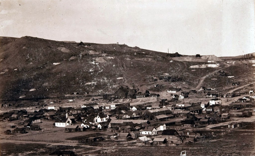
By 1890, Bodie had changed from a rough mining camp to a thriving town for families
(Public Domain, Wikimedia Commons)

Sanborn Fire Insurance map of Brodie, 1890 (Public Domain; Library of Congress)
Sadly, Bodie suffered two major fires, the first in 1892 and the second in 1932. Most of the residents of Bodie gave up and left town; by 1910 the population had already dwindled to approximately 698, and by 1920 to 120.
During World War II, the War Production Board ordered conversion of industries to war production which led to the last mine closing in 1942, followed by the closing of the US Post Office.
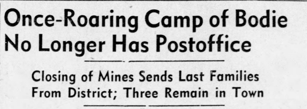
Reno Gazette Journal, November 26, 1942.
By 1962, Bodie was a ghost town, and the largest land owners, the Cains sold their holdings to the State of California.
A visit to Bodie is a step back in time, whether you want to believe the legends or the research. But keep in mind, Bodie is one of the coldest places in the lower 48 states of the US, based on Western Regional Climate Center records. As of 2012, the record high for July was 91F (33C), but the record low for July was 12F (-11C). The record low was -36F (-38C) in February.

Readings store postcard dated 1911. Courtesy of California State Library (Public Domain, published before 1922)
So shall we wander down a few of the streets in town to see some of the roughly 200 structures still standing in Bodie today?

James Stuart Cain and his wife, Martha Delilah Well, lived here. A lumber merchant and banker, he bought many of the properties in Bodie.

The only church left standing in town, the Methodist Church was built in 1882.

Interior of the church today.
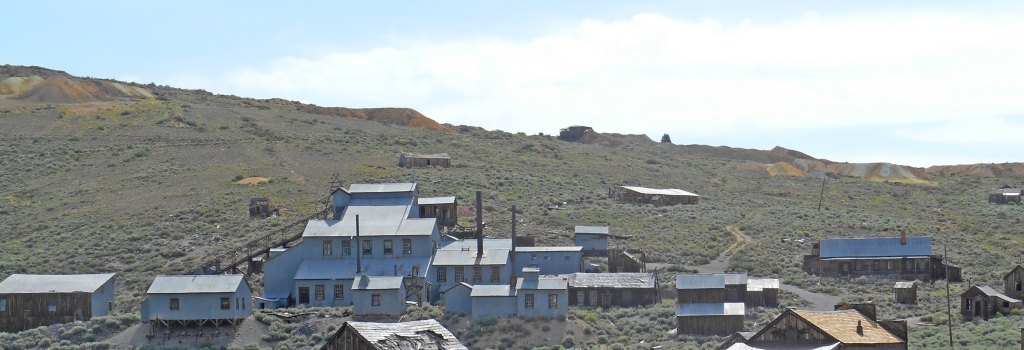
The Standard Consolidated Mining Company operated this stamp mill where ore was crushed to remove gold and silver deposits. The first mill on the site burned in October 1898 and was rebuilt, starting in 1899, adding corrugated steel siding and roof to the wood frame. Future U.S. President Herbert Hoover’s brother, Theodore was Superintendent of the Mill, circa 1905.

The vault of the Bodie Bank; the contents of the vault survived, but the building was destroyed by 1932 fire.

Boone Store and Warehouse, with Shell gas station to the right.

The wooden firehouse in a town known for fires. It was rebuilt by the California Conservation Corps in the 1930s.

The schoolhouse, built in 1879 as the Bon Ton Lodging House; when the last families with children moved away in November 1942, it closed.

The Swasey (or Swazey) Hotel (center) was probably a brothel. The Wheaton & Luhrs (or Wheaton & Hollis) Hotel is to the left across Green Street; it had various incarnations as land office, store and hotel. The confusion of names comes from overlapping painted signs where the paint is fading.

Through the window at the Wheaton and Luhrs.
Left to Right beginning with brick building: DeChambeau Hotel (built as the Post Office in 1879); Independent Order of Odd Fellows building; Miners’ Union Hall (built 1878), Morgue (smaller building on right)

A peek in the window at the morgue.
*There are lots of books and internet sites on the history of Bodie, and a lot of it is based on legend. If you want real history, the best I’ve found are http://www.bodiefoundation.org and http://www.bodiehistory.com. My blog isn’t intended to be as in depth as the history of town and mining deserve; I am only trying to give you a “taste” of Bodie!
**The spelling of his last name was somewhat inconsistent, some versions are Body & apparently his mother used Boddy; “Bodie” is supposed to be a mistake made by a sign painter. Even his first name has been cited as Williams, Waterman or Wakeman. The story of finding gold and Bodey’s death wasn’t recorded until 20 years later.
*** Legend has it that a little girl in Truckee in the 1870s learned her family was moving to Bodie, “a sea of sin,” and was overheard saying her prayers: “Goodbye, God, we’re going to Bodie.” When various newspapers picked up the story, the Bodie paper countered that it was a grammatical error and should have read: “Good, by God, we’re going to Bodie!”

While it may not look like much, there is a traveling mud pot in Imperial Valley, California, headed toward the Salton Sea. I went down there in November 2018, when the LA Times ran an article on it (https://www.latimes.com/local/lanow/la-me-ln-niland-mud-pot-20181101-story.html). At that time I couldn’t see it since the Union Pacific Railroad had guards protecting their work site as the mud pot (geyser) threatened their main line through the area (former Southern Pacific line).
The mud pot has been known to exist since the 1950s, but in 2015/16, it started moving at the rate of approximately 20 feet per year (https://www.nationalgeographic.com/science/2018/11/bubbling-pool-mud-moving-california-dont-know-why-geology/)! It is the only known moving mud pot.
In the Times article you will see an excellent map & an illustration showing its travel path and how the railroad installed a metal barrier in the ground, trying to stop it. The geyser just dove underground and came back up on the other side of the barrier.

Last week I went again and took these photos. The mud pot is now about 35 feet from the asphalt edge of State Highway 111. Traffic is now routed on a bypass, just to the west (https://dot.ca.gov/caltrans-near-me/district-11/current-projects/sr111-nilandgeyser). I was able to park just north of the bypass and walk down the “real” highway to the site of the mud pot. Although there are three low concrete barriers, you can easily walk around them.

Will it continue it’s journey to the west? Into the Salton Sea? Only time will tell.
This year has been a struggle for many of us; I am hoping to get back to HistoryTrove more often. This post is a change of pace, but needing to get out and go somewhere that I wouldn’t meet anyone, this trip was perfect.
Today, Poston is a small agricultural community in the middle of the Colorado River Indian Reservation in western Arizona. On the south edge of town stands a tall monument to the people of Japanese ethnicity interned in the Poston Camps during WWII. Three camps were built on the reservation over the objections of the Tribal Council; at their peak, over 17,000 people were interned for no reason other than they or their ancestors had come from Japan.
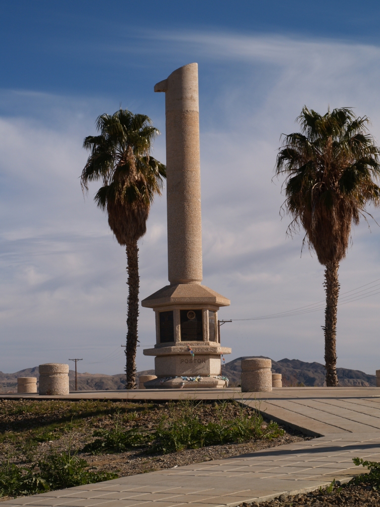
Plaque on the Memorial:
“This memorial is dedicated to all those men, women and children who suffered countless hardships and indignities at the hands of a nation misguided by wartime hysteria, racial prejudice and fear. May it serve as a constant reminder of our past so that Americans in the future will never again be denied their constitutional rights and may the remembrance of that experience serve to advance the evolution of the human spirit.
This memorial monument is erected in cooperation with the Colorado River Indian Tribes, former internees of Poston, Veterans and Friends of the Fiftieth year observance of the evacuation and internment.
October 6, 1992″


George Hirano was among the 611 internees who enlisted from the camps. Twenty-four internees from Poston Camp lost their lives fighting for the U.S. in WWII.
THAT DAMNED FENCE
(anonymous poem circulated at the Poston Camp)
They’ve sunk the posts deep into the ground
They’ve strung out wires all the way around.
With machine gun nests just over there,
And sentries and soldiers everywhere.
We’re trapped like rats in a wired cage,
To fret and fume with impotent rage;
Yonder whispers the lure of the night,
But that DAMNED FENCE assails our sight.
We seek the softness of the midnight air,
But that DAMNED FENCE in the floodlight glare
Awakens unrest in our nocturnal quest,
And mockingly laughs with vicious jest.
With nowhere to go and nothing to do,
We feel terrible, lonesome, and blue:
That DAMNED FENCE is driving us crazy,
Destroying our youth and making us lazy.
Imprisoned in here for a long, long time,
We know we’re punished–though we’ve committed no crime,
Our thoughts are gloomy and enthusiasm damp,
To be locked up in a concentration camp.
Loyalty we know, and patriotism we feel,
To sacrifice our utmost was our ideal,
To fight for our country, and die, perhaps;
But we’re here because we happen to be Japs.
We all love life, and our country best,
Our misfortune to be here in the west,
To keep us penned behind that DAMNED FENCE,
Is someone’s notion of NATIONAL DEFENCE!
From the National Archives

When I was growing up, one of my best friends was the daughter of a “Japanese-American” who had served in Europe, while his wife and their parents had been interned. They were as American as any of us.
